Dear Friends,
In the monthly report I sent you earlier today, I promised to forward the attached maps that show how many communities and how much critical habitat near Bethel and Kotzebue are underwater if either:
- Sea level from global warming rises 4 meters (13 feet), or
- Sea level from global warming rises 1 meter, and you combine that with 3 meter storm surges (which many communities bordering the Bering Sea experienced last year).
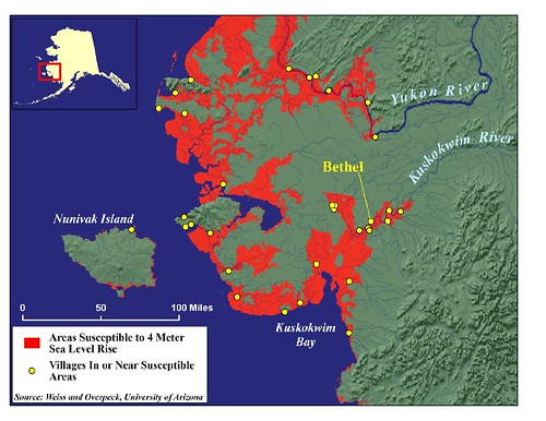
As you recall, in a study published in the journal Science last month, a team of scientists estimated that a sea level rise of from 4 to 6 meters could be dictated if we continue to increase CO2 emissions dramatically through the end of this century. Completed by ACE's GIS Center at the request of Susanne Fleek (ACF), the attached maps show the more conservative estimate: 4 meters.
Indeed, these cartographic images portray a dire, unacceptable scenario -- one that destroys numerous rural, culturally rich communities and much of the Yukon Delta National Wildlife Refuge's critical habitat for geese and other animals -- as well as other National Park, Refuge, and Native Village Corporation land. This would be tragic, costly, and, in some instances would cause irreparable and irreplaceable devastation and loss.
These inundation maps portray vividly one more reason why we need to act to reduce greenhouse gas emissions now. We can avoid this level of loss -- and we must.
In the next few days there will be several newspaper articles published in Alaska featuring these maps. I wanted you to have them immediately.
My best,
Deborah
Deborah Williams
Alaska Conservation Solutions
http://www.alaskaconservationsolutions.com/